I-GUIDE is empowering diverse communities to produce data-intensive solutions to society’s resilience and sustainability challenges.
I-GUIDE is empowering diverse communities to produce data-intensive solutions to society’s resilience and sustainability challenges.
The National Science Foundation (NSF) Institute for Geospatial Understanding through an Integrative Discovery Environment (I-GUIDE) integrates AI and cyberGIS, reproducible data-intensive analytics and modeling, FAIR data principles, and innovative education and workforce development programs to transform geospatial data-intensive sciences. This transformation catalyzes new convergence science to advance many fields, including computer, data, and information sciences, atmospheric sciences, ecology, economics, environmental science and engineering, human-environment and geographical sciences, hydrology and water sciences, industrial engineering, sociology, and statistics. I-GUIDE empowers various communities to generate data-intensive solutions to society's resilience and sustainability concerns through synergistic achievements in these disciplines.
Uniting Interdisciplinary Knowledge to Solve Real-World Problems! By fostering collaboration and providing access to advanced geospatial data capabilities, I-GUIDE is tackling fundamental scientific and societal challenges with innovative solutions.
U.S. dams are threatened by age-induced fragility and increased hydrologic stresses due to climate change. In many cases, communities and infrastructure below the dams have also increased dramatically over time, increasing the exposure to dam failure. Given that there are over 90,000 such dams in the United States, a traditional approach to dam risk assessment is challenging to implement. Our I-GUIDE project is taking an integrated approach to the application of “big data” sources so that a national or portfolio risk assessment of these assets can be attempted for the first time. This includes a spatially specific analysis of the climate changes of concern, of what is likely to be impacted if the dams fail, of the cascading effects of those failures on the national economy and other critical infrastructure elements, and the potential resilience of the infrastructure systems given the governance at different levels. The application of machine learning tools, statistical inference, natural language processing and the geo-hypercube together with traditional physics based and economics models are illustrated.
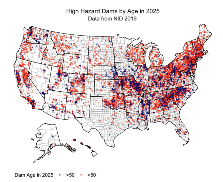
Concha Larrauri, P., Lall, U., & Hariri-Ardebili, M. A. (2023). Needs for Portfolio Risk Assessment of Aging Dams in the United States. Journal of Water Resources Planning and Management, 149(3), 04022083.
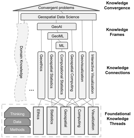
The Convergence Curriculum for Geospatial Data Science is an integrative framework to prepare next-generation students and current-generation scholars and professionals to tackle complex, convergent problems. This multi-tiered curriculum starts with 5 Foundational Knowledge Threads to establish a common basis for individuals coming from diverse backgrounds. Individual learners begin to integrate skills, knowledge, methods, and technologies as they move up through Knowledge Connections and Knowledge Frames. The pinnacle of the curriculum is Knowledge Convergence, which combines previous competencies with existing domain knowledge. Each component in the curriculum will be available at varying depths: 3 sentences, 3 slides, a 3-hour module, or a 3-week unit. This configuration allows individuals to adapt their experiences to match their learning pathways and needs.
Today there are massive volumes of text data, including for example news reports, research papers, and social media. Geospatial knowledge hypercube is defined as a multi-scale structure for integrating text data with heterogeneous geospatial data to discover latent connections and relationships through combining a variety of weakly supervised machine learning approaches. The hypercube lays a foundation for many knowledge discovery applications, such as recognizing geospatial entities and inferring geospatial relationships.

Geoethics promotes appropriate practices to shape responsible and sustainable relationships between human activities and Earth systems, bringing attention to the implications that researchers’ work may have on society. Promoting geoethics also requires fostering a positive relationship between the scientific community and the public. One critical concern of geoethics regards the use of geospatial data for AI applications. Large volumes of geospatial data are generated in multiple ways, including sensors from satellites, aircraft, and scientific instruments; geolocation-based data services; social media; and government surveys. Access, aggregation, and use of these and other data sources can promise many societal benefits, such as responding to humanitarian disasters response, and predicting and mitigating risks from aging infrastructure such as dams. However, using these data also raises thorny ethical issues, including transparency and accountability, privacy, bias and discrimination, and data and model quality. Even when appropriate safeguards are in place, it is still possible for unintended ethical harms to result. Geospatial data researchers, and those who use these researchers’ outputs, such as policymakers, must strive to mitigate the risk of these harms as they strive to solve major societal issues.

Join I-GUIDE's mailing list for updates on geospatial discovery and innovation. Stay informed on community priorities, cutting-edge data capabilities, and exciting advancements in various disciplines. Don't miss out on opportunities to participate in shaping the future of geospatial data-intensive sciences. Sign up now!